Jivdhan Fort
Type : Jivdhan fort is a hill fort
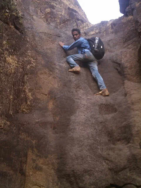
Difficulty level : Jivdhan fort is hard trek.
Height : Jivdhan is 3754 ft (1145 meters) above sea level.
Base village / District / Taluka : Ghatghar / Pune / Junnar, Maharashtra, India.
 |
| Entrance Of Jivdhan |
History of Jivdhan Fort.
The fort is from the satvahana era based on the carvings found on the entrance. The fort had an important value which was used to protect 'Naneghat' and the surroundings.
Traders received the help from the fort in very less time 'Bahmani' rulers had the control of the fort but they couldn't regain it for much time 'Nizamshah' took over the fort but in 1636 Nizamshah declined his empire 'Shahji Raje' rescued Murtiza who was the last nizam of the 'Nizamshahi' to the Pemgiri Fort, but he was later caught by the Mughals and this was the end of Nizamshshi dynasty.
As with every fort in 1818, Britishers captured the fort and destroyed it .the main entrance proves there attack of Britishers on the Kothi - Kothi means storehouse
which is only alone construction left
on the fort, the pillars are carved with rock and decorated with carving
arts ,It is huge mass and has been closed.
Time to reach the top
It will take around 2 hrs 45 mins from the base village.(Ghatghar)
Minimum Duration
1-2 days are enough as many spots can be seen nearby.
 |
| Hard to Trek |
Best time to visit the Jivdhan
Any Time but Monsoon is best time to visit the fort as fort can be enjoyed and is more adventurous in this season.
 |
| View From top Of the Jivdhan |
Water Availability
Yes water is available on Jivdhan.There are two water cisterns on the west side of the fort.
Accommodation Availability
Caves is available on Jivdhan, Also you can stay in Naneghat Caves or base village Ghatghar.
Places to visit on the Jivdhan Fort.
Water Cisterns, Vandarlingi, Northern Bastion, Kothi, Idol of Goddess Jivai.
Lets find How to reach to Jivdhan Fort.
Pune to Jivdhan Fort
From the Pune to Jivdhan there are ST (State Transport) buses (every one hour from Shivaji Nagar) or local transport are available to Junnar(91 kms),from Junnar to Ghatghar board bus or local transport are available(35kms)(Jivdhan).
 |
| View from Jivdhan |
From Kalyan there are ST (State Transport) buses available to Ale Phata or Ahemadnagar, there are buses regularly form to Ahmednagar it help to reach Vaishakhare. Naneghat originates from diversion at about 4 kms Vaishakhare.
 |
| Steps are Hard to Climb on Jivdhan |
Places to visit nearby the Jivdhan Fort.
Naneghat
Naneghat was used to guard four forts which were Jivdhan ,Hadsar,
Chavand and Shivneri from which Jivdhan is beside Naneghat .Kings
started capturing the area and they carved caves to stay in the caves.
The cave which is largest is carved with 'Brahmni' and 'Devnagiri'
scripts. Water cisterns were also made available to the traders tanks
are so well built that water is beard whole year around. 'Naneghatchi-
Nali' This tunnel is around 60 meters long and 2 to 4 meters in width
this route was built with stone that that transport would be carried
easily by bullock and horse carts .
Stone pot which is also called as
'Raanjan of Naneghat' Who's size is around 4 feet in height and 3 feet
in diameter this pot was used as to collecting money from the traders.
 |
| Naneghat Fort |
Chavand is the fort which was named as "Prassanagad" by the great maratha ruler 'Chatrapati Shivaji Maharaj' fort is named after the sages vasota (egs-vasitha).A controversy about the name is that locals couldn't pronounce "Chamunda" hence they started calling it as "Chavand" from here after.
Chavand fort is made by buddhist carvings and sculptures which proves it being ancient the mountain of Shambhu & the fort of Jivdhan on the west, Hadsar on the north, Shivneri on the east & the route of Naneghat along the fort.
The grandson of seventh Nizamshah whose name was 'Bahdurshah' was imprisoned here in 1594.In 1636 treaty was signed by the father of 'Great Shivaji Maharaj','Shahji raje' signed treaty with Mughals, in which Mughals got Chavand .After the rule of Marathas fort was captured by britishers .In 1818 the fort was completely destroyed by them and even the route was destroyed by them.
 |
| Hadsar Fort |
This fort is at an height of 3200 ft and medium located near hadsar village.Hadsar was known as 'Pravatgad', this fort was used to control the trade route in between Naneghat.
Which was constructed during Satvaahanas and was habited heavily during this time it is situated near Ahmednagar (called as 'nagar' by the locals), hadsar was exchanged by Shahaji Raje in the treaty of 1637 with mughals. Britishers destroyed this with other forts in this region in the year 1818 and most of the features of the forts were destroyed by them.


